Summary
Approximately 38% of the EU budget (equivalent to 0.4% of the Union’s GDP) is spent on agriculture and rural development mainly through the Common Agricultural Policy (CAP) (EU agriculture spending report, 2015). Furthermore, in the EU, the agricultural area covers slightly less than half of the territory; therefore CAP is a policy that can have a major impact on the environment. In the province of Navarra (North-East of Spain), the Agriculture sector makes a significant contribution to the region´s economy. Given the huge difference in the distribution of these subsidies across the sector, it would be interesting to assess whether a similar type of difference is evident in the environmental health of the farming practices they follow.
This project explores the relations between the amount of subsidies granted to the Agriculture sector of the Spanish province of Navarra during 2015 and the beneficiaries’ environmental practices, as evidenced by the region’s environmental datasets available at the Navarra’s government website.
The analysis has demonstrated the existence of relations amongst the environmental, agriculture and economic indicators covered, particularly between levels of risk erosion, crop yield and CAP subsidies.
Overall, subsidies in the region of Navarra seem to be working, as the relation between the environmental indicators covered and the subsidies seem to follow expected trends, i.e. those perceiving higher subsidies are:
-
- working the land using practices causing lower levels of risk erosion,
- working in areas with habitats showing sustainable levels of biodiversity,
- less prone to use irrigation farming although this is not difficult given the levels of precipitation on the region.
The results are encouraging but there was missing information, such as the consumption of fertilisers in the region, which ought to be incorporated to the study because the results currently generated require further processing to be more reliable.
Another opportunity for improvement would be by working directly with the records available in the SIGPAC system, the GIS managed by the Spanish government. As it holds the records of all the farms supported by CAP funds, it would enable more accurate computations. Currently this data is only available to view which makes it difficult to include in external workflows.
Data Sources: the records of all the Navarra CAP beneficiaries were downloaded from the “Spanish Agrarian Funding Guarantor” (FEGA is the Spanish acronym). The environmental indicators included in the study are:
-
- The level of risk erosion by water as estimated by the European Soil Data Centre
- The vulnerability of the Natural habitats identified in the region. The layer includes a qualitative indicator describing the “health” of the habitat in terms of the biodiversity level identified.
- The distribution of the landscape (the status of the mountainous areas). This was complemented by an elevation data model extracted from the European data portal.
- The status of the Nitrate Vulnerable Zones identified in the region.
The agriculture indicators covered are:
-
- Navarra’s cereal crop production. As cereals are the main crops grown in the region, the study did not include any other.
- The type of farming, which could be: rain-fed, irrigation.
- The distribution of the pasture lands. The dataset included two relevant factors: the distribution of livestock units (LSU) across the pasture lands, the area of land.
The website of the Government of Navarra was the main source of information. It provided both environmental and agricultural datasets. In the previous list unless otherwise stated, the indicator was obtained from the Government of Navarra.

As there is a reasonable mixture of both, geographic and socio-economic data, the analysis was performed in three phases, using both ArcGIS and Excel. Furthermore, as most of the input layers use the GCS “ETRS89 / UTM zone 30N”, all the processing was done using this coordinate system.
Data Processing

Initially, numeric data was extracted from the geographic datasets using ArcGIS tools: attribute table operators (for shapefiles) and Zonal statistics (for raster files). This output was then integrated with the economic data in Excel and an initial set of conclusions were drawn regarding the relations between environmental indicators, agricultural and economic factors for the different agricultural regions in Navarra (Tables 1,2).
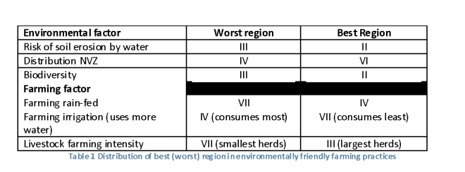
The results estimated in this first step are summarised in Table 2. For each Environmental factor considered (column 1), the worst behaved (column 2) and best behaved regions (column 1) have been identified. The results suggest that the behaviour varies across the regions. It also indicates that overall farming practices in region III seem to be the ones requiring the most improvement. On the other hand, the CAP beneficiaries in region II seem to be the most environmentally inclined.
Regions I, V, VII are not registered at all which although is good from the perspective of “worst performance”, also seems to suggest the need for further improvement.
In order to perform the spatial analysis (main aim of the study)), it was necessary to update the records in ArcGIS, adding the subsidies data in Excel to the data stored as geographic datasets.
- The economic data was integrated with the geographic layer holding details of the different Navarra agricultural regions (shapefile).
- The environmental factors were available both as raster and shapefiles therefore the integration worked in a slight different manner in each case.
- All the layers (shapefiles) holding agricultural information were integrated using a combination of Spatial Join operations. The same procedure (Spatial Join) was used to integrate all the layers (shapefiles) holding records of environmental factors.
- The data in the raster files was added using the Zonal statistics tool.
- In a final step, it was necessary to integrate the Environmental layer and the Agricultural layer resulting from the previous steps into one layer holding all the records. The resulting dataset includes all the economic, environmental and agriculture data collected. This dataset is used in the subsequent steps to assess the relations between all the indicators using a spatial analysis method.
- The spatial analysis uses two ArcGIS tools: Exploratory Regression (ExpRegr) and Ordinary Least Squares (OLS). Both require the specification of a dependent variable and a set of explanatory variables. In this study, the dependent variable was the SUBSIDIES granted through the EU CAP scheme. The explanatory variables correspond to all the environmental and agricultural factors described earlier.
- The Exploratory Regression tool was used to determine the best combination of explanatory variables which should be used to specify an OLS model for predicting the “dependent variable” (SUBSIDIES).
- The best set of explanatory variables identified in the previous step was fed to OLS. This tool performs global Ordinary Least Squares (OLS) linear regression and enabled the modelling of the dependent variable (SUBSIDIES) in terms of its relationships to the set of explanatory variables, providing a fairly good idea of the existing dependencies between them.
Results
The best set of environmental and agricultural indicators to model CAP subsidies in Navarra, that were identified using the Exploratory Regression tool are:
Risk Erosion (MEANRISKER, units: tonnes*ha-1*yr-1)
Elevation (MEANDEM, units: meters)
Mountainous indicator (CZONA_ZM, qualitative: Alta Montana, Desfavorecida, Montana, Normal)
Habitat vulnerability (VGLOBNUM, qualitative indicator:1 – 12)
Yield Cereal (rain-fed) (TOTPRODCERSEC, total tonnes)
Pasture lands indicator (CCAT_NUM, qualitative indicator: heads LSU)
NVZ vulnerability (VULNER_NUM, qualitative indicator: Nula, Baja, Media, Alta)
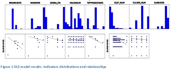
A book of maps, one page for each element included in the model, is available. The book includes distribution of CAP subsidies through Navarra, distribution of LSU through Navarra’s pasture lands, crop yield, risk of erosion, elevation, distribution of mountainous regions, natural habitats biodiversity level, and a vulnerability level of the NVZ areas. It also includes a scatterplot of SUBSIDIES against each of the indicators in the model (Figure 1).
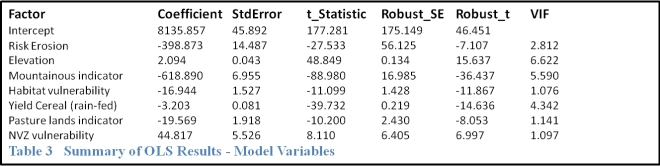
The OLS model estimated by the tool is shown in Table 3. The results show they are all significant. Nevertheless, of the model indicators there are two (Koenker (BP) statistic, Jarque-Bera Statistic) which are statistically significant (p < 0.01) showing it is likely the relationships modelled are not consistent and there is evidence of model bias.
Common sources of model bias include: non-linear relationships, data outliers. The OLS scatter plot matrix (Figure 1) shows evidence of both in the model developed. The analysis has demonstrated the model is probably missing key explanatory variables. It has also indicated the existence of relations amongst all the indicators covered, particularly between level of risk erosion, crop yield and CAP subsidies.
Overall CAP subsidies, at least in the region of Navarra, seem to be working, as the relation between each of the indicators covered and the subsidies are following expected trends, i.e. those perceiving higher subsidies are:
-
- working the land using practices causing lower levels of risk erosion,
- working in areas with habitats showing sustainable levels of biodiversity,
- less prone to use irrigation farming although this is not difficult given the levels of precipitation in this part of the world.
The only concern is associated to the management of NVZ. The current results appear to indicate higher subsidies linked to higher levels of vulnerability. Nevertheless, the lack of information on the use of fertilizers in the region, complicate the task of concluding anything further in this regard.
The Navarra local authorities do include a wealth of information which was very useful for the purposes of this study. Nevertheless, an estimation of the GHG emissions was not possible because:
-
-
- the information on livestock was not sufficiently detailed,
- nor was the energy consumption or the use of fertilizers.
-
The distribution and vulnerability of NVZ across the regions was used instead. The analysis can be improved with more appropriate data on livestock and use of fertilizers.
The results suggest that the highest beneficiaries from CAP subsidies might not follow the expected environmental practices.